


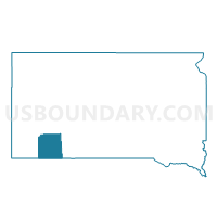
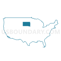
VTD-precinct ShrpsCorner, Shannon County, South Dakota
About
Outline

Summary
| Unique Area Identifier | 667763 |
| Name | VTD-precinct ShrpsCorner |
| County | Shannon County |
| State | South Dakota |
| Area (square miles) | 215.78 |
| Land Area (square miles) | 215.76 |
| Water Area (square miles) | 0.02 |
| % of Land Area | 99.99 |
| % of Water Area | 0.01 |
| Latitude of the Internal Point | 43.49608110 |
| Longtitude of the Internal Point | -102.40102410 |
Maps

Graphs
Select a template below for downloading or customizing gragh for VTD-precinct ShrpsCorner, Shannon County, South Dakota


Neighbors
Neighoring Voting District (by Name) Neighboring Voting District on the Map
- VTD - SC11, Pennington County, SD
- VTD - WL15, Pennington County, SD
- VTD-precinct CunyTable, Shannon County, SD
- VTD-precinct Kyle, Shannon County, SD
- VTD-precinct Manderson, Shannon County, SD
- VTD-precinct Porcupine, Shannon County, SD
Top 10 Neighboring County Subdivision (by Population) Neighboring County Subdivision on the Map
- West Shannon UT, Shannon County, SD (8,153)
- East Shannon UT, Shannon County, SD (5,325)
- East Central Pennington UT, Pennington County, SD (384)
- Imlay township, Pennington County, SD (7)
Top 10 Neighboring Place (by Population) Neighboring Place on the Map
Top 10 Neighboring Unified School District (by Population) Neighboring Unified School District on the Map
Top 10 Neighboring State Legislative District Lower Chamber (by Population) Neighboring State Legislative District Lower Chamber on the Map
Top 10 Neighboring State Legislative District Upper Chamber (by Population) Neighboring State Legislative District Upper Chamber on the Map
Top 10 Neighboring 111th Congressional District (by Population) Neighboring 111th Congressional District on the Map
Top 10 Neighboring Census Tract (by Population) Neighboring Census Tract on the Map
- Census Tract 116, Pennington County, SD (6,720)
- Census Tract 9408, Shannon County, SD (4,745)
- Census Tract 9409, Shannon County, SD (4,422)